


From Village Land Use Plans to Key Biodiversity Areas: Unlocking Tanzania's Hidden Conservation Potential
Author: Shadrack Stephene Achilla, Directorate of Research, Compliance and Information (DRCI), National Land Use Planning Commission (NLUPC), Dodoma, Tanzania
An archive invisible to KBA and OECM reporting
Village land use planning in Tanzania is a statutory process whose enabling laws and guidelines also sit within the country's broader environmental and international commitments, yet its practical contribution to Key Biodiversity Area and OECM processes remains, to date, largely unexplored. Under the Village Land Act of 1999 and the Land Use Planning Act of 2007, village assemblies work with district land use planning teams to zone village land into categories that typically include residential and agricultural areas, grazing land, water source protection zones, and Village Land Forest Reserves. NLUPC coordinates and archives the resulting plans nationally, with approximately 4,900 approved plans, roughly 40 percent of registered villages, as of mid-2026. The archive is a large and fast-growing record, not a census, and any use of it for conservation purposes has to work with that incompleteness rather than around it. Its statutory purpose was, and remains, to resolve land disputes, secure tenure through Certificates of Customary Right of Occupancy, and give district authorities a basis for land administration decisions, objectives that leave real, and largely unassessed, conservation value sitting inside the archive rather than reaching the bodies that could use it.
What VLUPs can and cannot do for Key Biodiversity Areas
Key Biodiversity Areas work on a demanding test. The Global Standard for the Identification of Key Biodiversity Areas, published by IUCN in 2016, sets eleven criteria across five categories, and a site only qualifies with quantitative evidence of species populations, ecosystem extent, or ecological integrity against fixed global thresholds. A village land use plan cannot supply that evidence, and this article is not arguing that it can. What the Standard's delineation procedures do call for, once a site is otherwise under consideration, is attention to land tenure and socio-economic context alongside the ecological data, and that is the layer village land use plans hold at village scale across the whole planned archive: tenure status, customary boundaries, and zoning decisions for grazing corridors, water catchments, and forest patches, mapped down to a resolution of individual land parcels within a single village (Figure 1). The more immediate use is upstream of delineation. Tanzania's KBA network is thin outside gazetted protected areas, particularly across rangeland and forest-agriculture mosaics where field assessment resources are scarce and where research on joint village land use planning has already documented preserved wildlife corridors and livestock-wildlife coexistence. Reading the VLUP archive for zones with that profile gives assessment teams a shortlist of villages worth visiting first. It narrows a search. It does not identify a KBA, and the difference matters enough that it should stay explicit every time this argument is made.
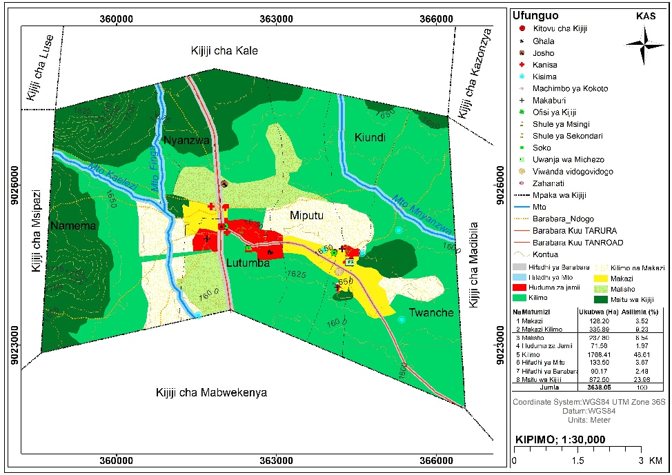
Figure 1. Proposed Village Land Use Plan for Kiundinamema village, Kalambo District, prepared in 2025. Credit: NLUPC.
What VLUPs can and cannot do for OECMs
The Convention on Biological Diversity defines an OECM as a geographically defined area, other than a protected area, governed and managed in ways that achieve positive and sustained long-term outcomes for the in situ conservation of biodiversity. The IUCN WCPA site-level tool for identifying OECMs, published by Jonas, MacKinnon, Marnewick and Wood in 2023, breaks that definition into eight criteria applied in three steps, and tests outcomes separately from governance. Village Land Forest Reserves supply the governance half of that test well: they are geographically bounded within an approved plan, governed by a village council under statutory authority, and subject to locally enforced rules restricting extraction, the kind of rule set physically posted at reserve boundaries (Figure 2). A zoning designation on paper is a governance fact, not evidence that biodiversity in that zone is being conserved, and the two should not be treated as interchangeable. Uisso, Chirwa, Ackerman and Mbwambo's 2019 before-and-after study of the Kilosa REDD+ initiative provides the clearest peer-reviewed evidence available: it found village participatory land use plans associated with improved forest management practice and reduced extractive pressure inside Village Land Forest Reserves. That is an important governance and management result, but it stops short of the sustained, positive biodiversity outcomes the OECM criteria require. Any VLUP zone put forward as an OECM candidate still needs a site-level assessment against the full criteria before it is reported.
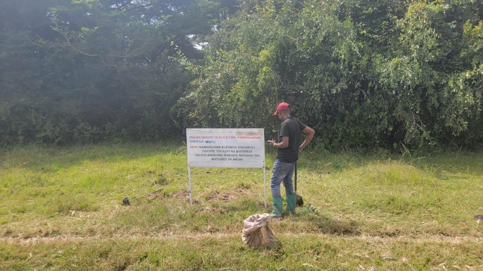
Figure 2. Village Land Forest Reserve signboard stating prohibited activities, management rules, and bylaw penalties. Credit: NLUPC.
Why the potential stays hidden
Tanzania's narrow KBA coverage outside gazetted protected areas, and its OECM under-reporting, reflect institutional invisibility of existing evidence as much as any absence of qualifying sites on the ground. Village land use plans are held at district level, often on paper, with no standard template for extracting the fields a conservation assessment needs. NLUPC's mandate sits inside land governance, organizationally separate from the bodies that nominate and confirm Key Biodiversity Areas or report OECMs internationally. A plan approved in a district land office has no routine channel to reach a KBA National Coordination Group assessment table, even when the reserve it describes has been under active village management for years. This is not a purely technical gap. Village-level governance capacity varies considerably across districts, plans are unevenly enforced, and a zoning decision recorded in one village's plan does not guarantee the same standard of management in the next. Screening on VLUP data has to carry that variation forward rather than average it away.
What would need to change
Three things would connect the archive to both processes without overstating what it can prove. First, a standardized field-level extraction protocol that converts VLUP zoning categories into the specific governance and management fields a KBA or OECM screening step can use, rather than leaving each district's records in incompatible formats. Second, a direct data-sharing arrangement between NLUPC and Tanzania's KBA National Coordination Group, so candidate sites move from a district archive into a national assessment pipeline as a matter of routine. Third, and non-negotiable, field verification of conservation outcomes, not just governance structure, before any VLUP-derived candidate is treated as a confirmed KBA lead rather than a screening result or reported nationally or internationally as an OECM.
If a standardized extraction protocol, a formal data-sharing arrangement with the KBA National Coordination Group, and mandatory field verification of outcomes can be established, the VLUP archive can move from incidental utility to a routine, evidence-based input into both KBA prioritisation and OECM identification, without ever claiming to substitute for the ecological data those processes require.
References
- Brockington, D. (2007). Forests, community conservation, and local government performance: the village forest reserves of Tanzania. Society and Natural Resources, 20(9), 835-848.
- Huggins, C. (2018). Land-use planning, digital technologies, and environmental conservation in Tanzania. Society and Natural Resources, 31(11), 1279-1293.
- IUCN (2016). A Global Standard for the Identification of Key Biodiversity Areas, Version 1.0. Gland, Switzerland: IUCN.
- Jonas, H. D., MacKinnon, K., Marnewick, D., and Wood, P. (2023). Site-level tool for identifying other effective area-based conservation measures (OECMs), First edition. IUCN WCPA Technical Report Series No. 6. Gland, Switzerland: IUCN.
- NLUPC and Ministry of Lands, Housing and Human Settlements Development (2026). Internal communications on national Village Land Use Plan coverage, mid-2026.
- Uisso, A. J., Chirwa, P. W., Ackerman, P. A., and Mbwambo, L. (2019). Forest management and conservation before and after the introduction of village participatory land use plans in the Kilosa district REDD+ initiative, Tanzania. Journal of Sustainable Forestry, 38(2), 97-115.
- International Livestock Research Institute, KINNAPA Development Association, and Tanzania Natural Resource Forum. Why joint village land use planning is critical for protecting Tanzania's remaining rangelands.
-
WWF, IUCN World Commission on Protected Areas, and The Nature Conservancy (2023). 30x30: A Guide to Inclusive, Equitable and Effective Implementation of Target 3 of the Kunming-Montreal Global Biodiversity Framework.